

I’m back! In fact, I submitted my DPhil nearly a month ago. The reason there’ve not been any posts yet is I haven’t known what to write. (If you have any ideas, the contact form is thataway.) In the end I decided to take inspiration from Diamond Geezer, whose blog has been, even when not directly so, a huge influence on my own. In particular, this week DG asked himself which grid squares he’d been to in the Ordnance Survey National Grid. Not wanting to write a direct rip-off, I decided to put my own twist on it: which local authority areas have I been to in my life, either for the day, to stay overnight, or to live?
The answer, give or take, is that I’ve been to 144 out of 368 in Great Britain. The more philosophical answer is that asking this question was a bad idea.
Indeed, this post is going up on Monday because I spent all of Sunday on the data, including a phone call to my mum in which she reminded me of various places I’d forgotten about, and some I still don’t remember. It doesn’t help that local authorities are vaguely arbitrary in their boundaries, and not always associated with a major settlement, so it’s possible to cross a boundary without realising it. I can’t guarantee even now that all of what follows is accurate. But I do think the results say something interesting about where I tend to go, in normal times—and about how even though I think of myself as well-travelled within the UK, there are some parts that I’ve hardly seen at all.
Let’s get the technical stuff out of the way. I’m answering the question about GB because I downloaded my boundary data w from the Ordnance Survey, which covers Great Britain only, as opposed to from the Office for National Statistics (ONS), which covers the whole UK. This doesn’t make a huge difference because I’ve not actually been to Northern Ireland (or anywhere on the island, in fact), but it’s irritatingly incomplete; if you could NI, I’ve been to 144 out of 379 districts. (I only discovered that the ONS even held boundary line data when I came to use its datasets for which region and nation each local authority was in, and by then I was too deep into the process to start again.)
I did all this using those data¹, and the “tidyverse” and “sf” libraries in the language R. (Full attribution for the data and R is at the end.) As well as for the map-plotting itself, I used R to write some code that asked me the following questions of each area:
- Have you been there? If so:
- Have you blogged about it?
- Have you stayed overnight? If so:
- Have you lived there?
I decided on some rules for myself about what counts as having “visited”. I decided that passing through in a vehicle didn’t count, and neither did stopping at a service station (else I could have had Blaby, home of Leicester Forest East services), nor changing trains without leaving the station (else I could have had Preston). Then there are edge cases: if I changed from a train to some other mode of transport I counted that, unless it was a rail replacement bus (which is functionally a train). This is definitely arbitrary, but I had to draw a line somewhere.
So here’s the map:
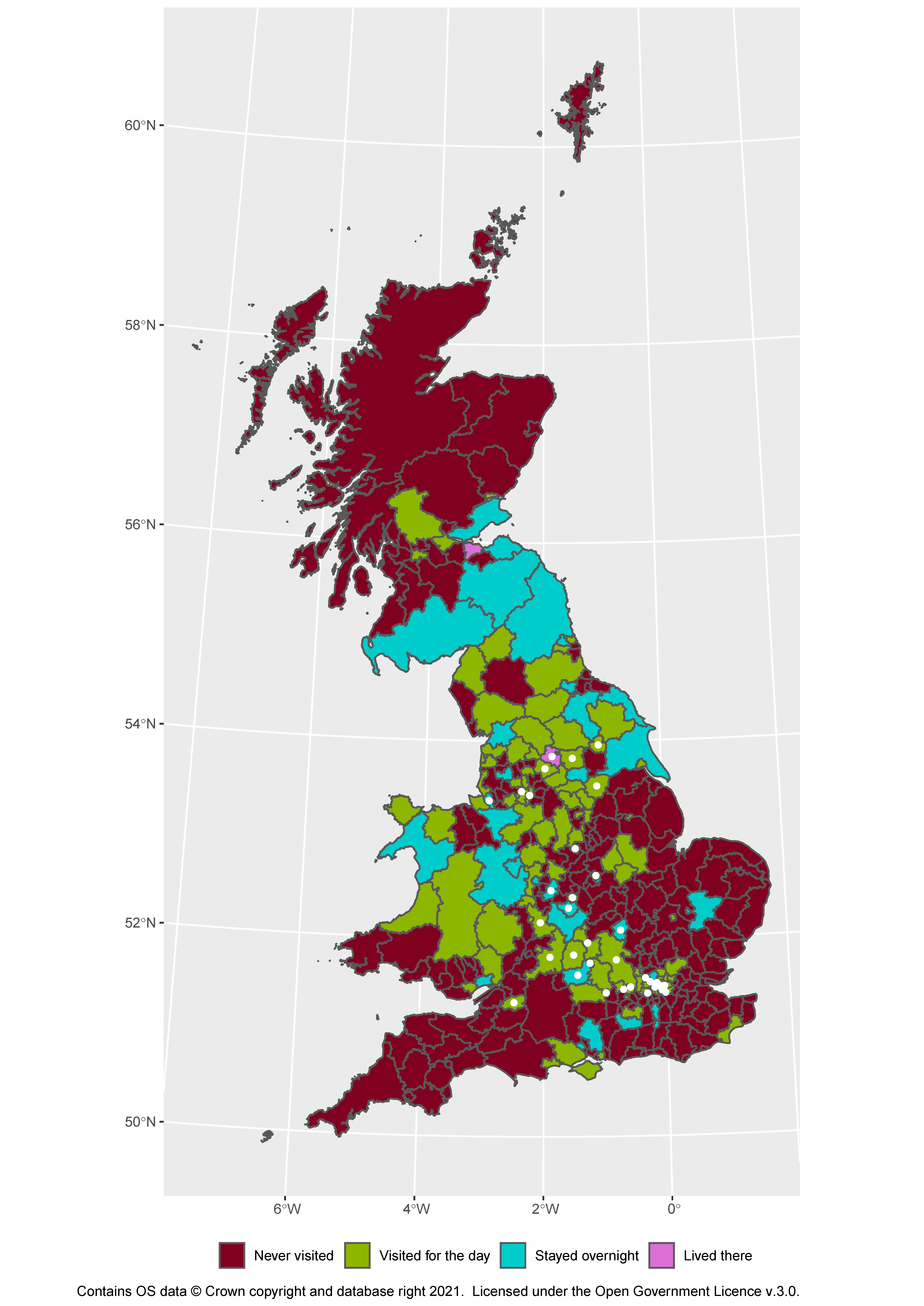
(Here and throughout, the white dots represent places I’ve blogged about.) I imagine you’ll agree that this is hard to decipher. So let’s work through the country, roughly from south to north.
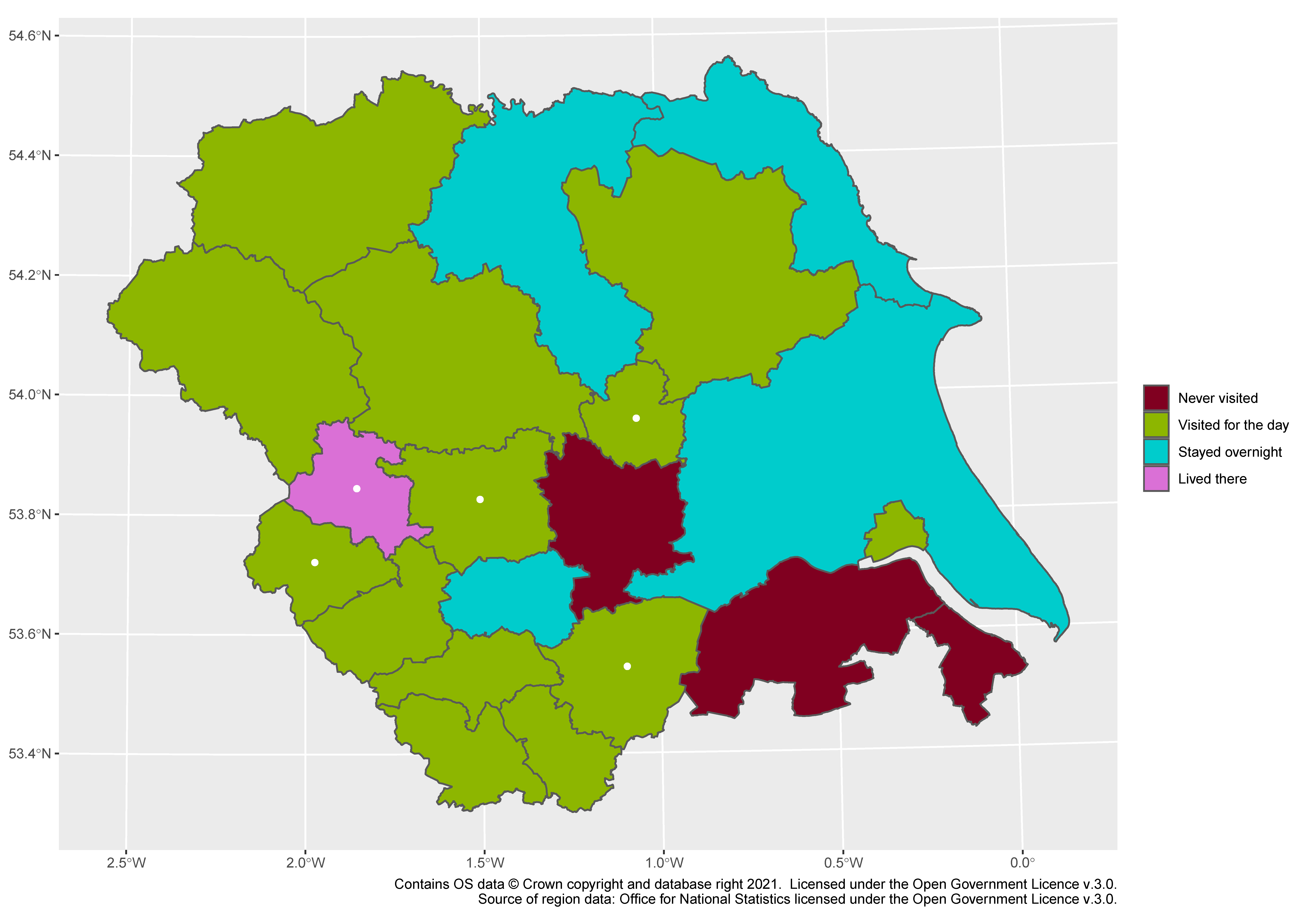
South East
Here is the first of the three purple places-I’ve-lived districts, which is Oxford. It’s unsurprising that I’ve been to all of Oxfordshire, given this blog’s original purpose, though I never got around to writing about anywhere in the South Oxfordshire district; I always meant to go back to Didcot Railway Centre, which I visited long before I’d started this project. Buckinghamshire (east of Oxfordshire) would have been more patchy, but last year it all got merged into one district, barring Milton Keynes. (Because of COVID they’ve not been able to hold elections yet, which means the council is made up of a whopping 199 councillors, being every councillor from the old district and county councils.) And then I’ve been to a few bits of Berkshire (south of Oxfordshire), including Slough (unfortunately) and West Berkshire (on an ill-fated trip to Ikea).
Beyond that it gets a lot more sparse: a few nights in Southampton help with Hampshire and the Isle of Wight, but beyond that it’s a school trip here, an airport hotel there, and not much else. Overall I’ve barely scratched the surface of Kent and Sussex—largely because to get to them by train from Oxford or Bradford you have to change in London, which makes it more impractical to visit. Speaking of London…
London
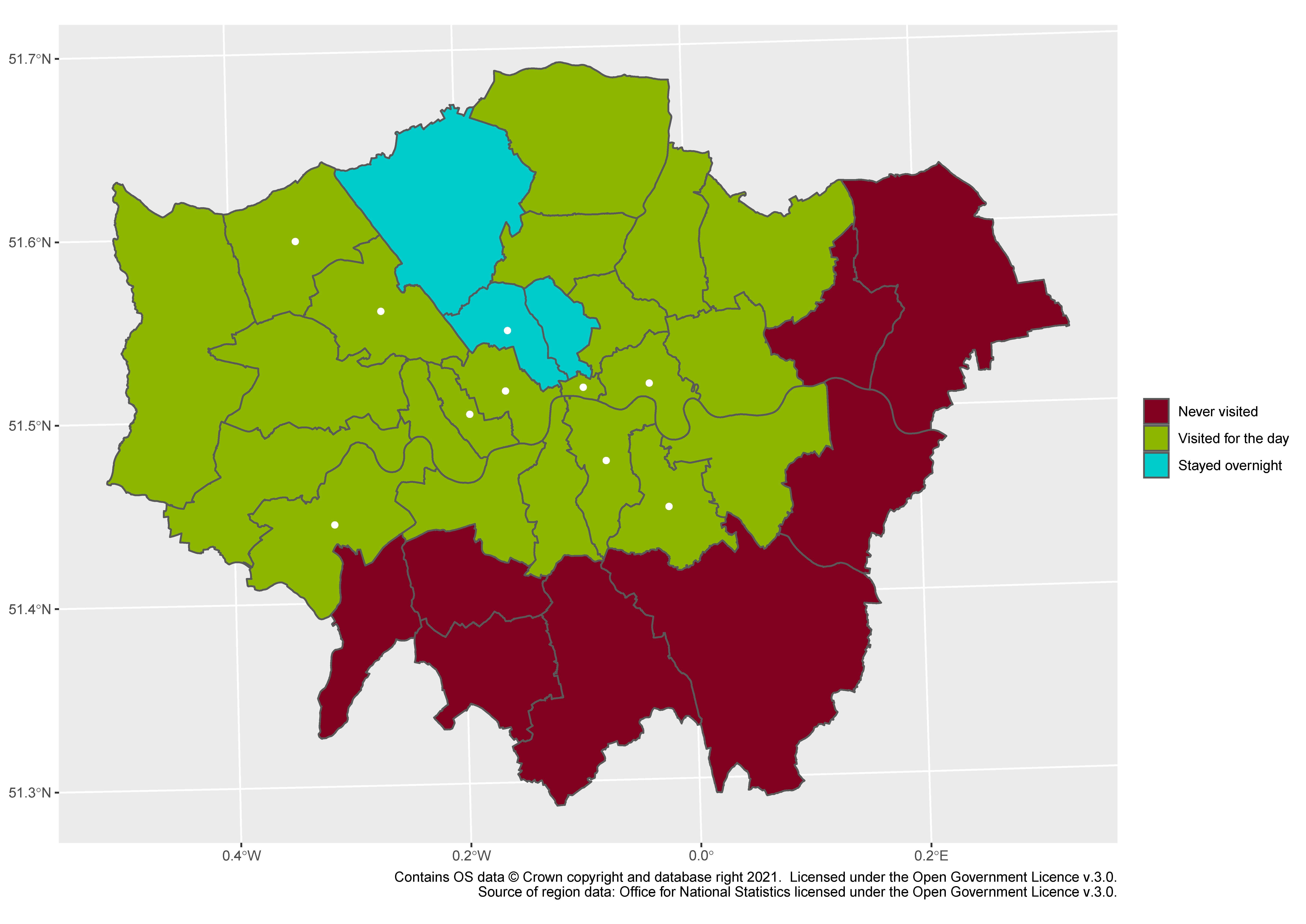
This is easily the most satisfying of the maps. The boroughs I’ve stayed in form a contiguous whole, surrounded by a contiguous area of boroughs I’ve visited but not stayed in, surrounded by a contiguous area of boroughs I’ve never been to. There’s a heavy bias towards the north and the west, influenced partly by my approach to London being from those directions when living in Bradford and Oxford (Hillingdon only appears because I’ve changed there from the X90—RIP—to the Tube into town). You can also easily see the sweep of places that I visited for my random Tube journey, which ended up being a random walk up and down the Bakerloo line. But the problem with the satisfying map is that there’s not much else to talk about, so let’s move on.
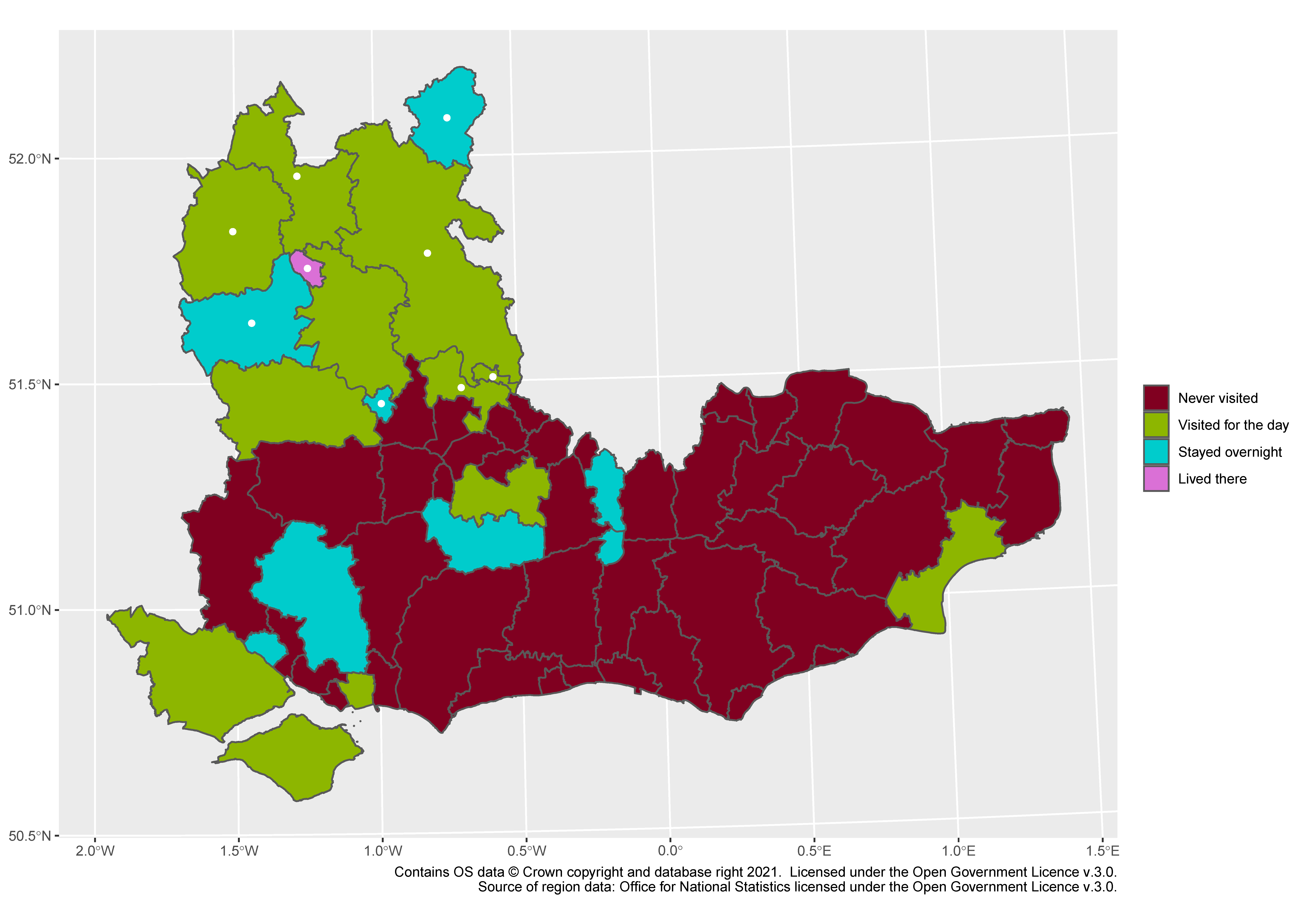
South West
Oh dear. The local authority boundaries here make it look better than it is: I’ve not covered much of that large green area, and for the blog I just scraped the north-eastern corner when I went to Moreton-in-Marsh. Cheltenham, Bath and North East Somerset, and BCP (Bournemouth, Christchurch and Poole) complete the awesome foursome here, and this is the only nation or region (except Northern Ireland) that I’ve never spent the night in. A performance so embarrassing I might have to flee the country, so it’s lucky our next stop is…
Wales
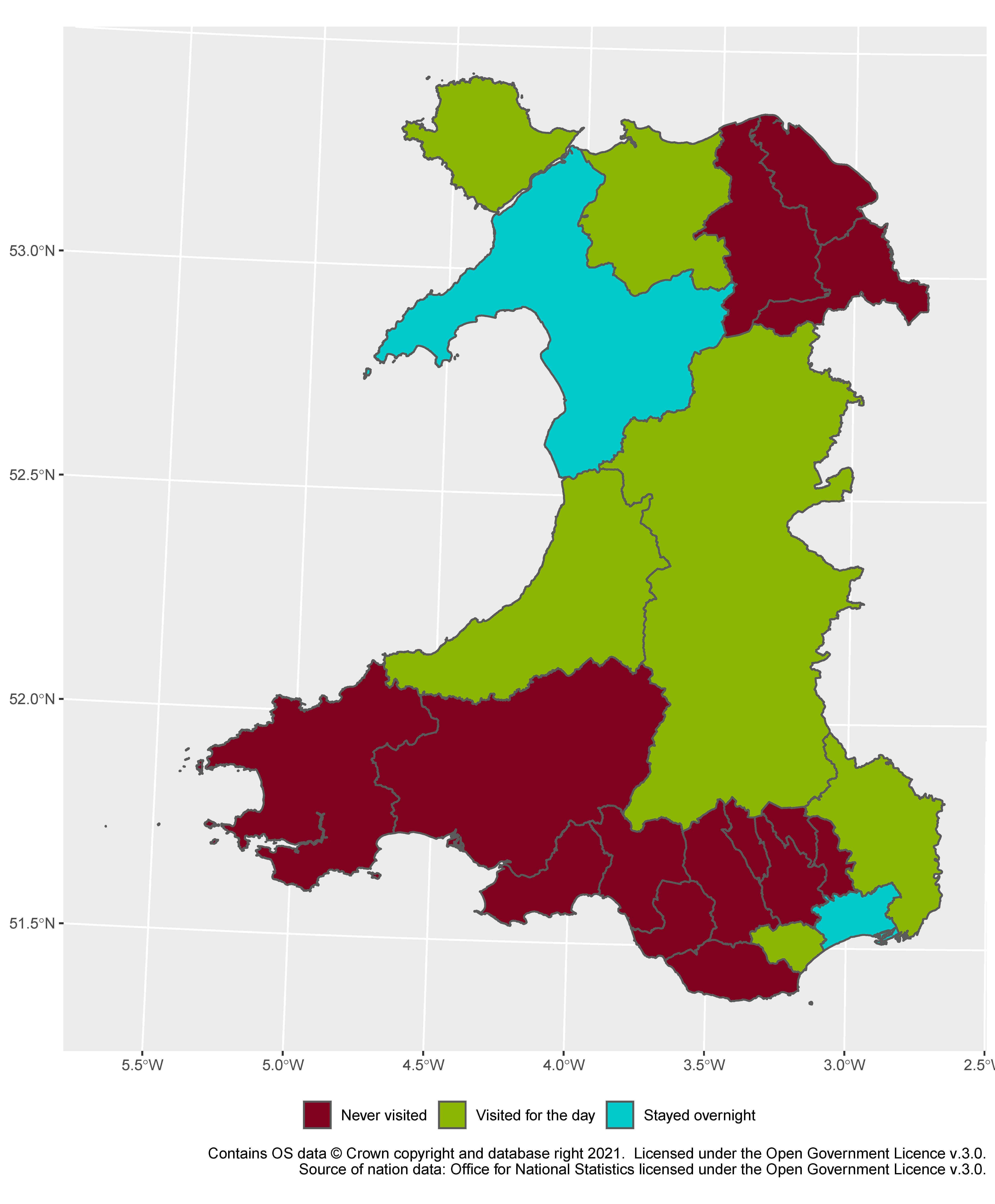
This is mildly satisfying, with all the “visited” areas joining up, showing neatly that it’s the remoter areas (from a Bradford/Oxford standpoint) that have remained unvisited. Annoyingly, I’ve actually stayed in three places in Wales, but two of them are at nearly the extreme opposite ends of Gwynedd, so I only get two blue council areas. Luckily one of the ones I’ve been to, though, is Powys, which takes up most of eastern mid-Wales, and gives me a vast swathe of colour that I don’t really deserve. But you can’t take it away from me: after all, we’ll always have Powys.
West Midlands
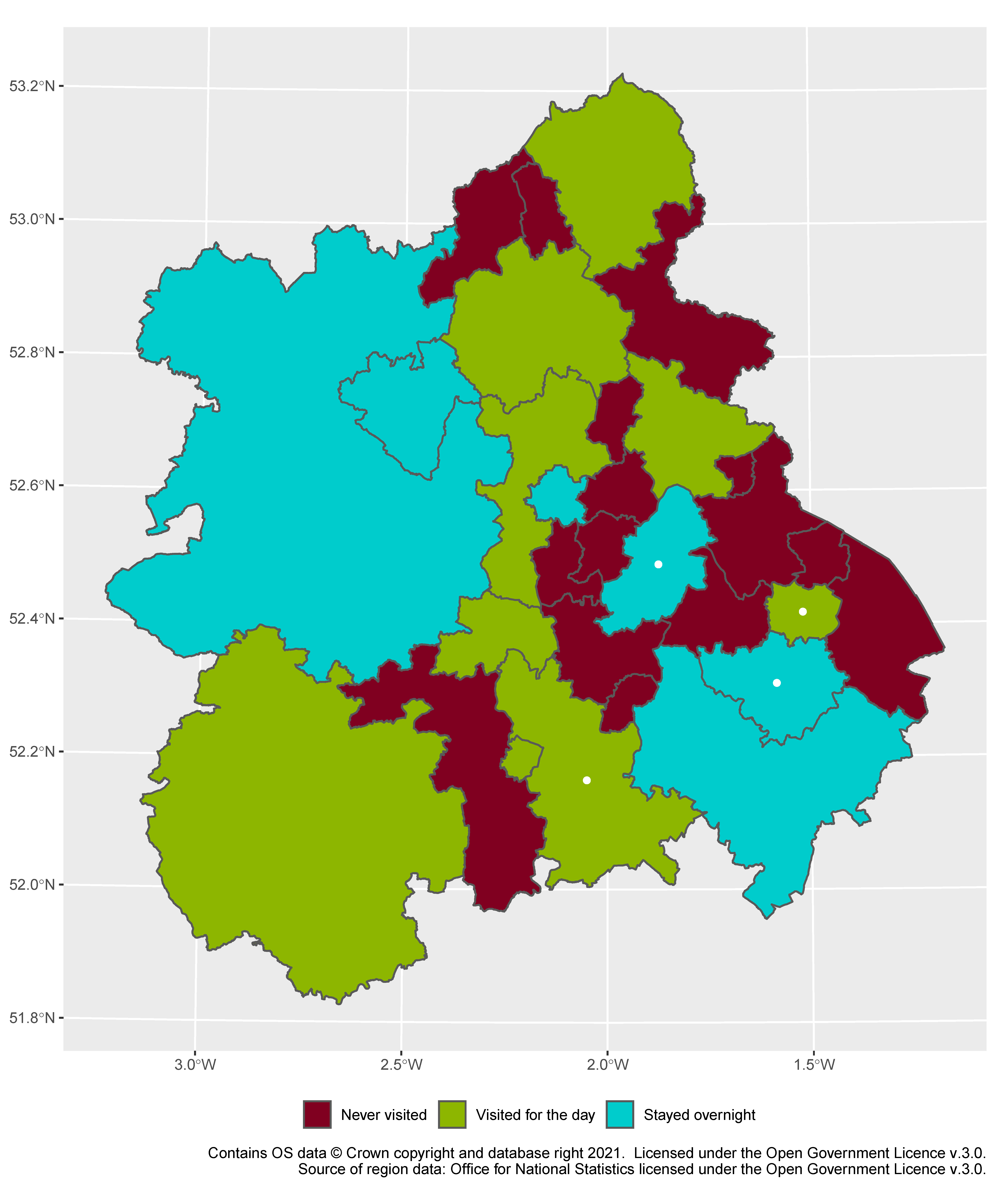
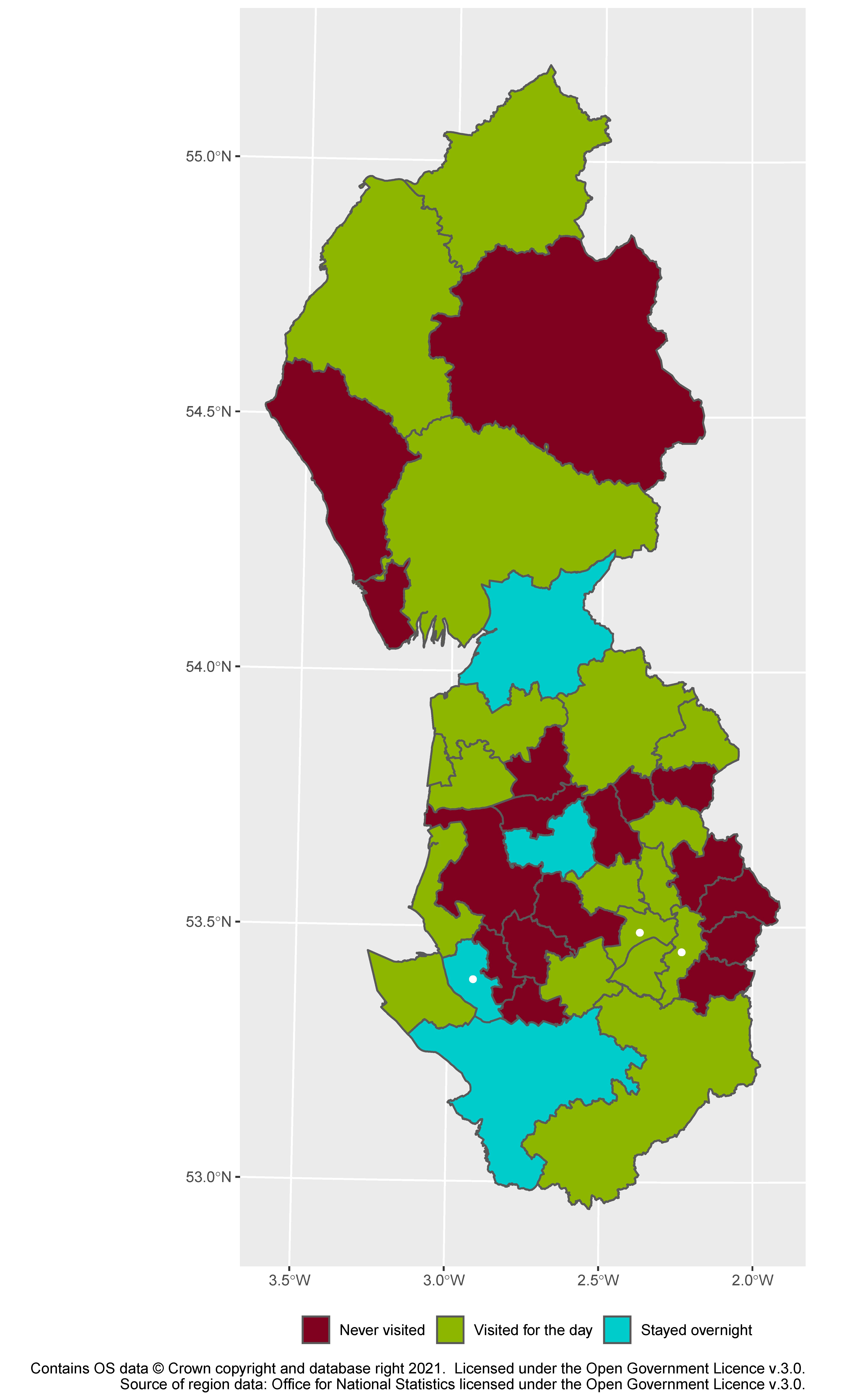
This map shows very clearly the problem with this approach to mapping out where I’ve been. Thanks to local government reorganisation, Herefordshire (the big green area to the south-west) has had one big district council since 1998,² and Shropshire (the two blue areas in the north-west) has had only two since 2009.³ In the case of Shropshire, I really have been to most of it (I’ve been to all but the smallest of the old six districts, all of which I’ve spent the night in⁴) but in the case of Herefordshire the merger causes a gross overestimation (I’ve been to Hereford, but that’s about it). The real surprise here for me was Staffordshire (at the north-east)—I thought I’d hardly been, but I kept turning up new districts when I peered closely at the map (Staffordshire Moorlands from a childhood trip to Alton Towers, for instance).
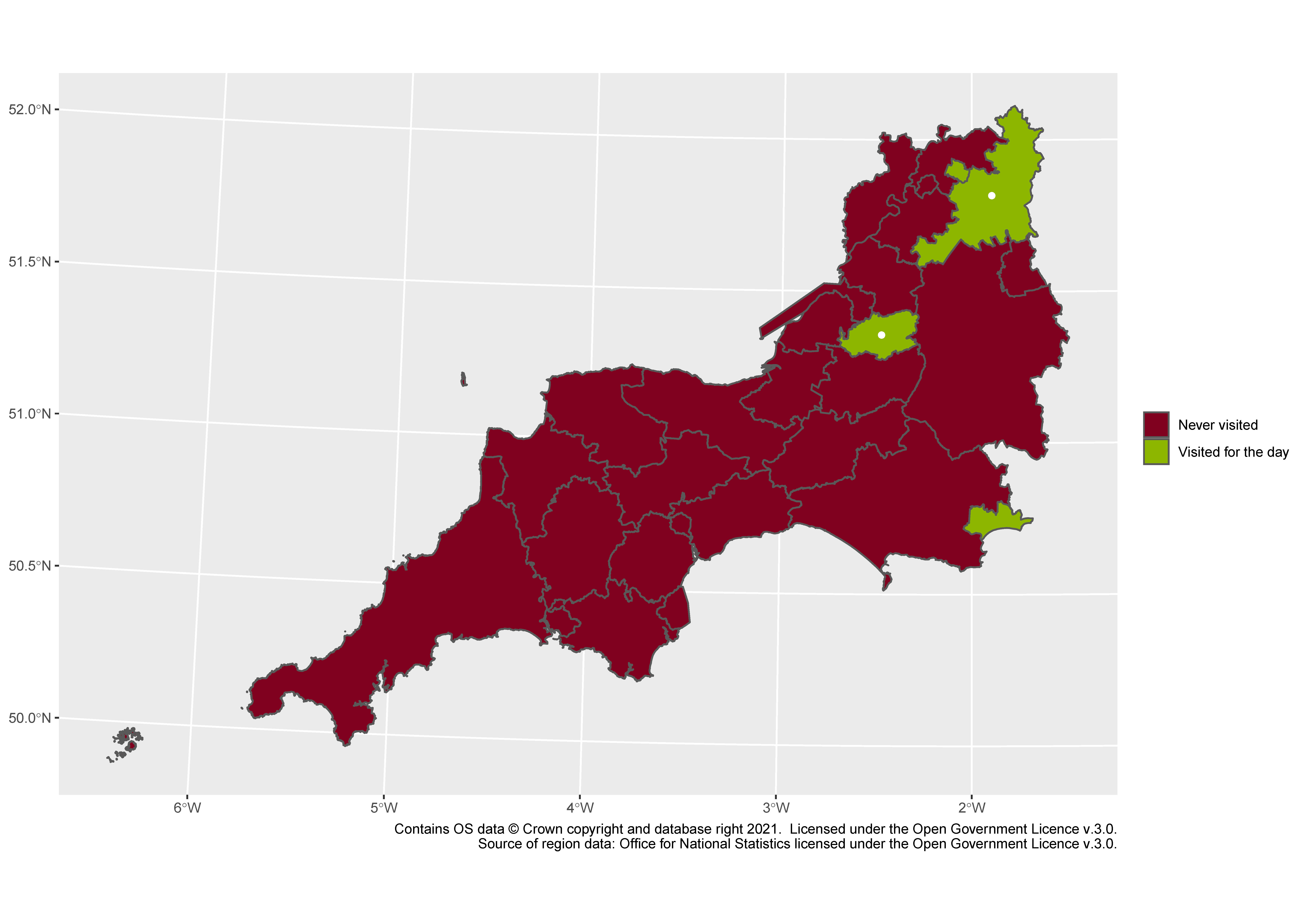
East Midlands
My mum was a big help here, because it turns out I’ve been to many of Derbyshire’s stately homes when we used to have membership of the National Trust. That ticks off a lot of the little districts in the north-west of the map. But otherwise, I’ve given the East Midlands rather short shrift, except for its cities—two of the dots of green/blue are the Leicester and Lincoln areas, surrounded by a sea of red—and an area around Rutland, arguably England’s smallest county.⁵ So I think this map shows more clearly than any other that I really am less of a small-town girl⁶ than a city boy⁷–or perhaps it just reflects that public transport is harder in rural areas than in urban ones.
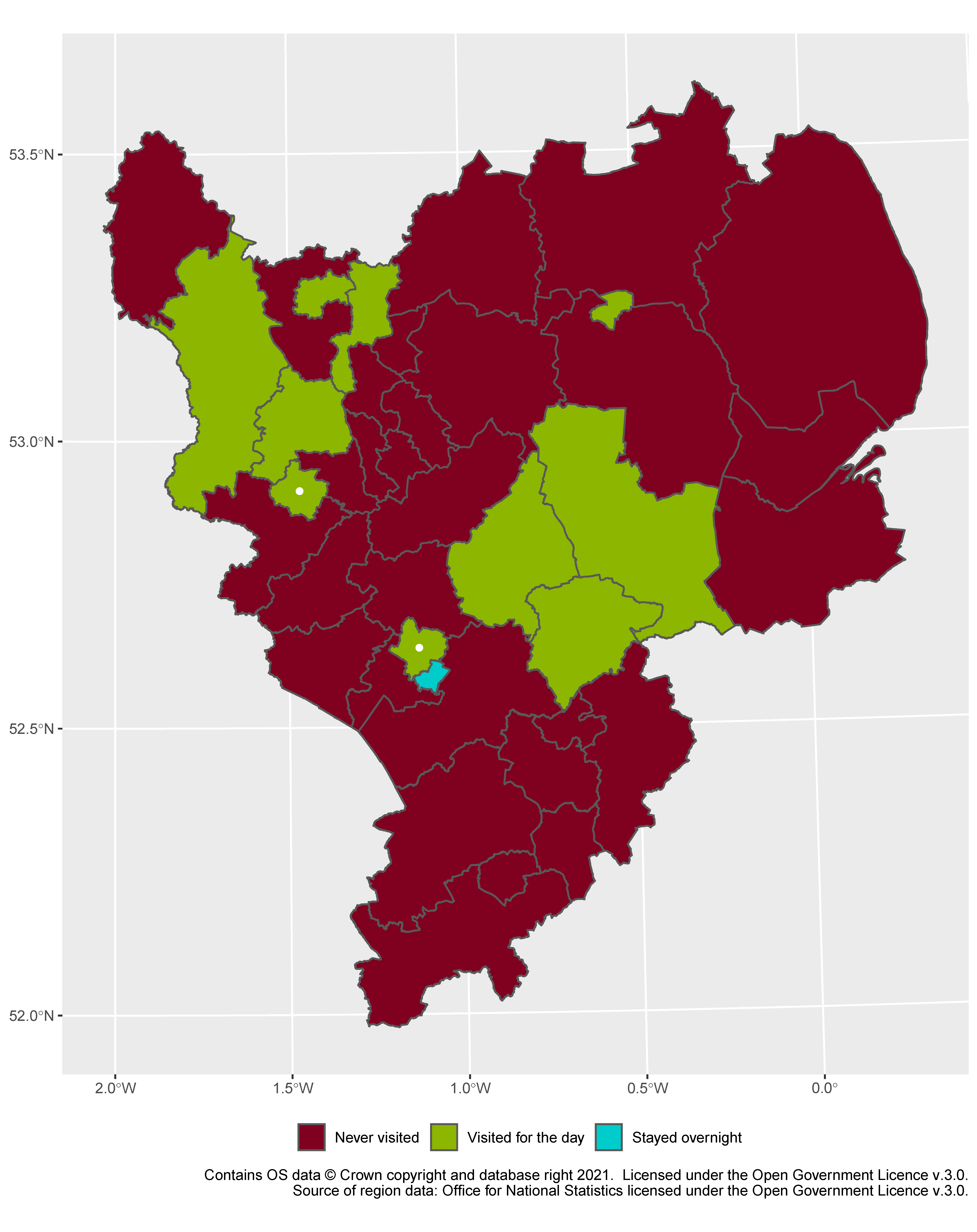
East of England
Another near-washout: a few places near London, and then the “Silicon Fen” area around Cambridge. Again the boundaries are misleading: there’s only one big blue region near the middle of the map, which narrows to a thin neck between the smaller part to the west and the larger one to the east, and I’ve only been to the small western lobe. Nothing to see here.
Yorkshire and the Humber
My home county,⁸ unsurprisingly, is well-visited (the only bit of Yorkshire itself that I’m missing is Selby), and the areas near my hometown of Bradford are fairly well-blogged too (at least, for places that are a long way from Oxford). Even though the areas are listed by “how seriously” I’ve visited, one thing that’s noticeable here is that the extremes of the scale, in a way, bend into a horseshoe—because if an area is inaccessible, either you stay there overnight or you don’t go at all. So I’ve stayed in both areas along the Yorkshire coast, and in the Dales, but I’ve not been to Scunthorpe and Grimsby in the south-east, places whose very names make you want to run away across the Pennines.
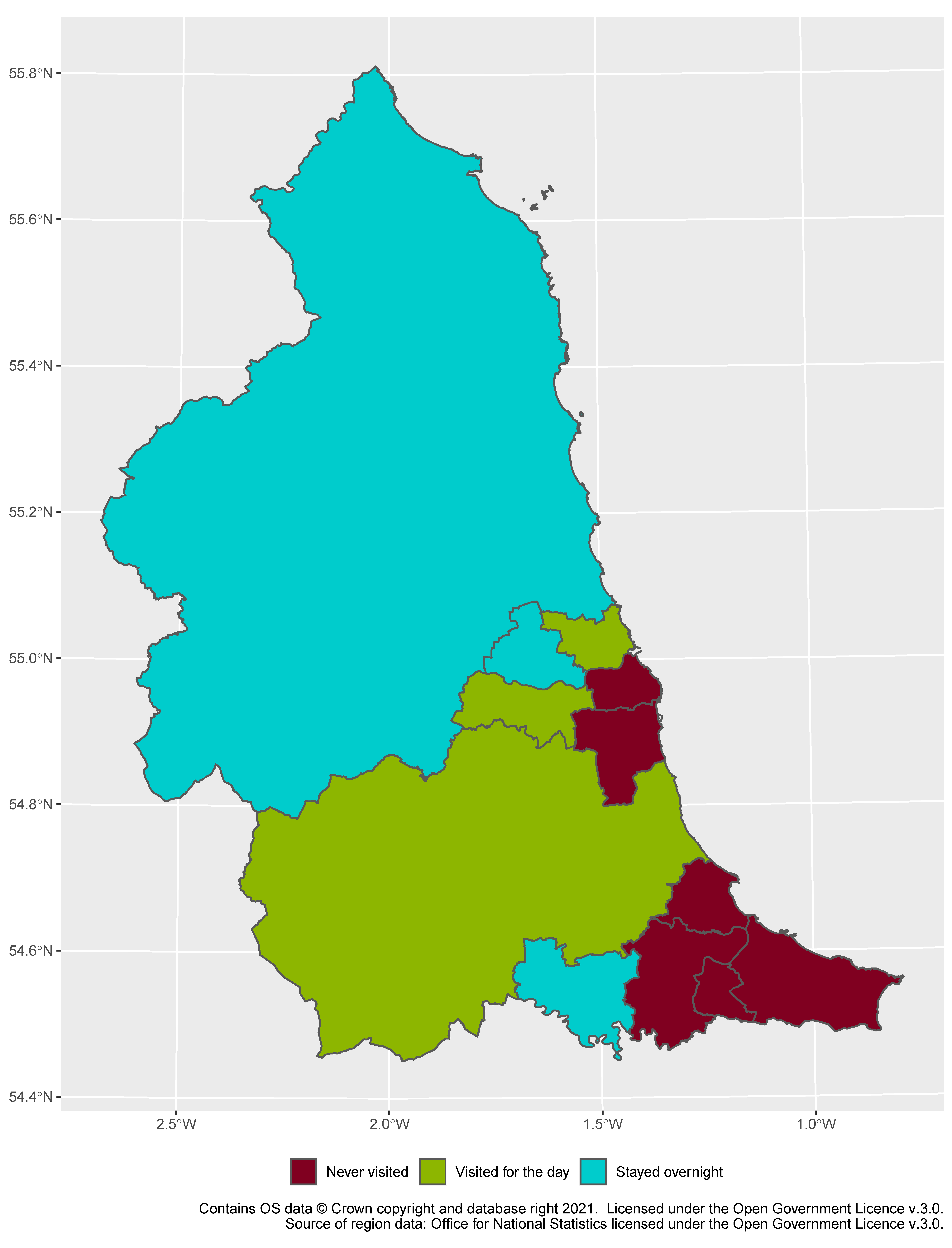
North West
I defy anyone to find a pattern in this. I’ve been some places, but others I haven’t. Some of them I’ve stayed in, and some of them I’ve blogged about. It’s a fairly high level of coverage overall, helped by the fact that the lower loop of this figure-of-eight-shaped region is the largely urban Lancashire and Cheshire, while the upper loop contains the Lake District, about the limit in distance for a day trip by car from Bradford. Fun administrative geography fact: the blue region at the pinch point and the green region at the very top are two of the largest cities in England by area, Lancaster and Carlisle, respectively. Carlisle is actually the largest; both cities contain substantial amounts of moorland. Finally, it’s topical to note that I’ve been to Cheshire East, the south-easternmost green region, because I’ve been to Lyme Park; it’s less than eight miles as the crow flies away from Handforth.⁹
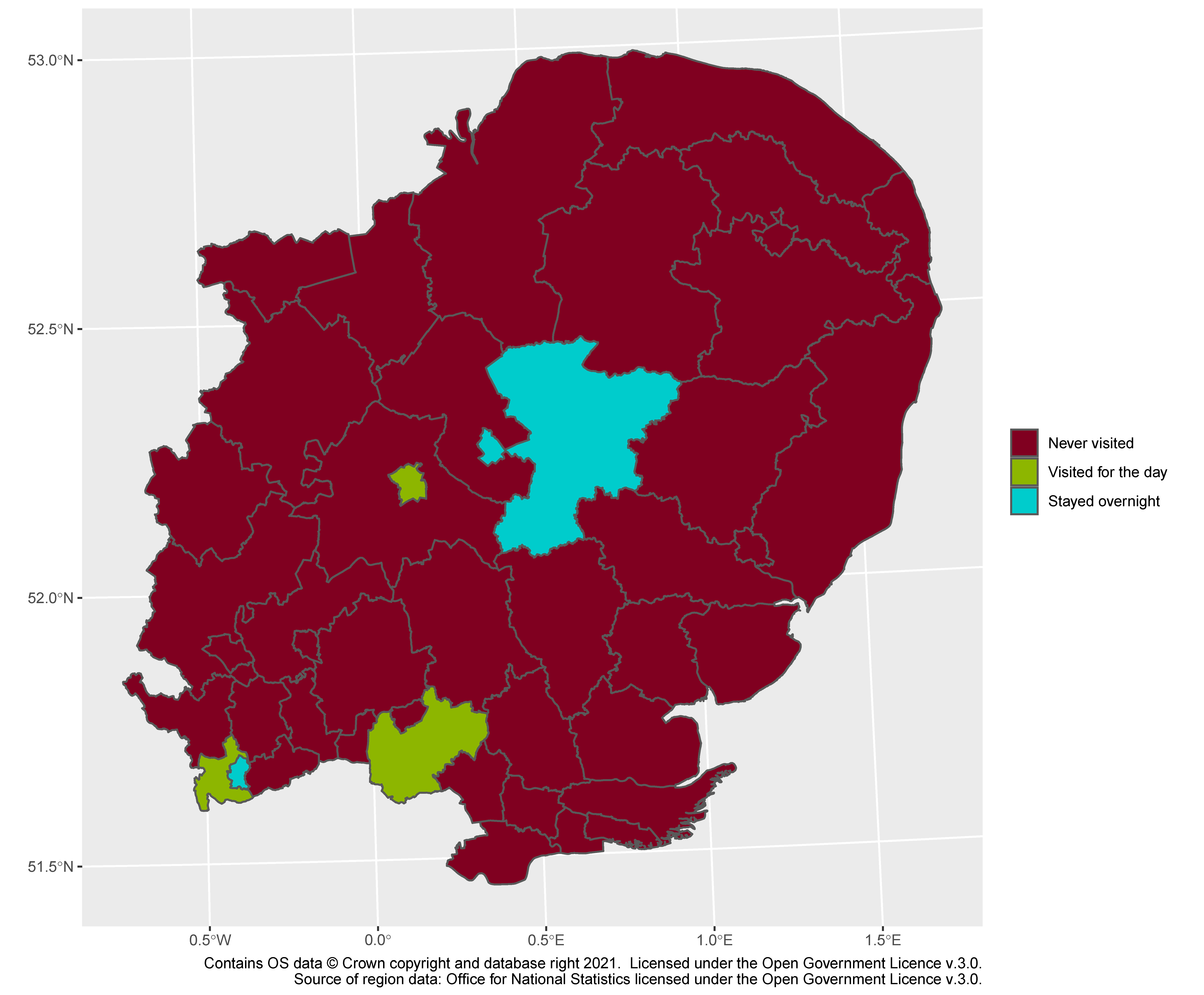
North East
Concluding England is its northernmost region. Here Northumberland and County Durham are like Shropshire and Herefordshire in the Midlands, having been stripped of most of their districts, and so I get a sweeping coverage I don’t deserve, or at least that isn’t comparable with other parts of the country. In Northumberland I’ve been to the urban south-east and the coastline further north, but never really to parts on the inland side of the A1. In Durham (the county) I’ve only really visited Durham (the city). I’ve never had a reason to visit Teesside at all.
Scotland
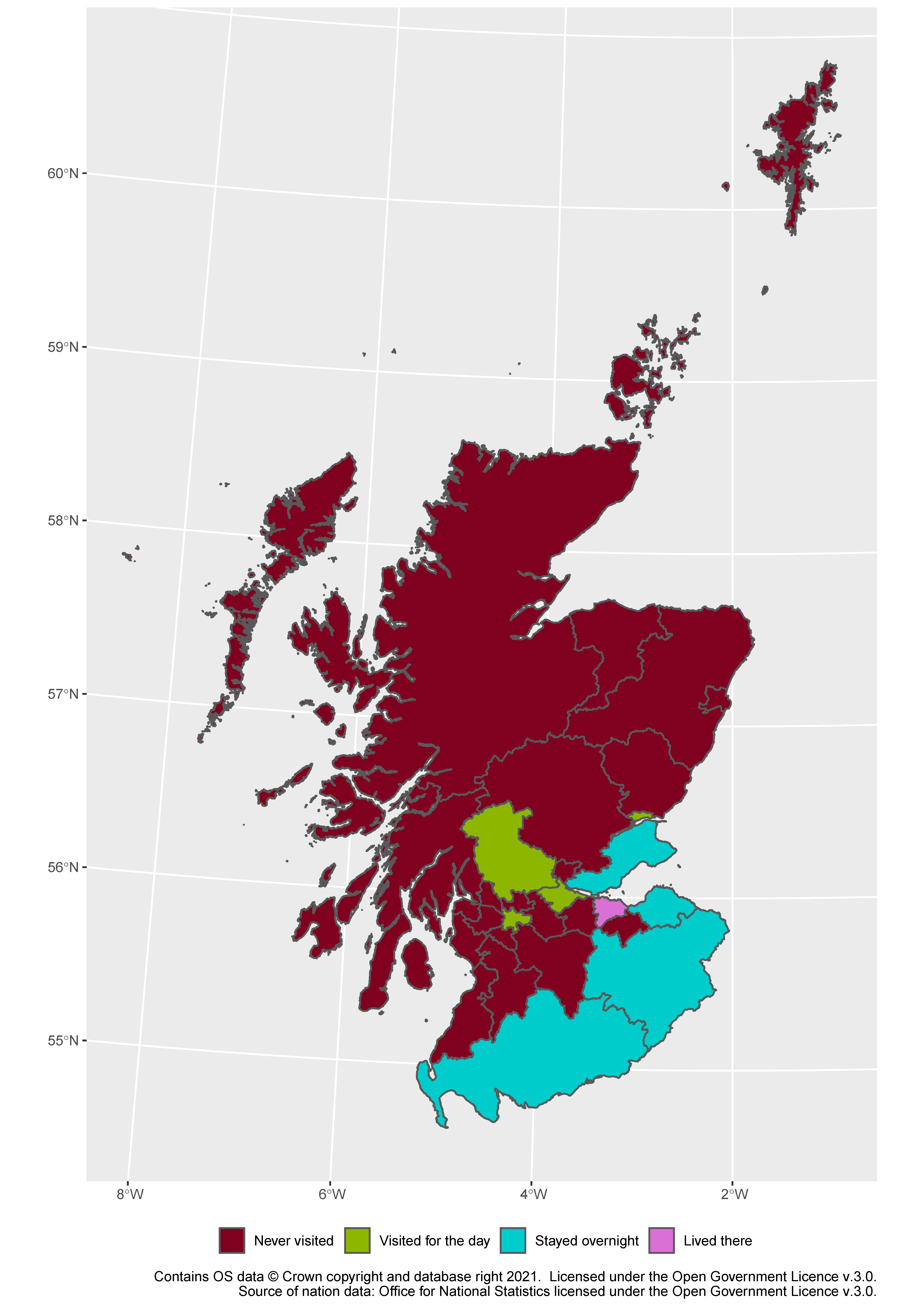
And we end in the region containing my new home, Edinburgh. Perhaps unsurprisingly, the other places I’ve stayed from a belt near the border, plus Fife. Glasgow comes up green because I went to the Commonwealth Games there in 2014, among other trips, but because the hotels were so expensive we stayed in Edinburgh and “commuted”. Scotland’s council areas mostly match the urban–rural divide, but I get credit for a large area poking into the Highlands because I’ve been to Stirling. You can tell from this that I moved during a pandemic: I’m sure in normal times I’d have made it to the other two Lothians surrounding Edinburgh, but I only went to Fife, somewhere I’d already been, before COVID Level 3 kicked in.
And that’s Great Britain done. Would I recommend doing this yourself? No. It was a laborious process of checking off districts, and my memory is hazy enough that some of the colours are just best guesses. But if you used something more easily identifiable, like counties, or postcode areas… Then definitely. If nothing else, once we can move around again, I expect I’ll be consciously trying to turn more of the map green.
The maps in this post were made using open data from two government sources:
- The Ordnance Survey BoundaryLine dataset which contains OS data © Crown copyright and database right 2021. Licensed under the Open Government Licence v.3.0.
- ONS lookup tables for which region and UK nation the districts belonged to. Source: Office for National Statistics licensed under the Open Government Licence v.3.0.
The maps were made using R, and specifically the “tidyverse” and “sf” packages.
¹ I have been trained that “data” is a plural word, as opposed to the singular “datum”, so the correct form is “those data are” rather than “that data is”. I appreciate this might be irritating if you consider “data” to be synonymous with the unambiguously singular “dataset”. But we accept that “trousers” takes plural forms, even though you’re (presumably) only wearing one.
² Though before that it hadn’t had a county council, being part of Hereford and Worcester.
³ Telford and Wrekin remained separate, having been removed from the control of the county council in 1998, but the other five districts were merged with the county.
⁴ In fact, it was on the first night of one of these staycations, in the quaint little town of Ludlow, that child-me first internalised my own mortality. I’ve no idea what about Ludlow caused this, but that was a rough week, and I’ve been rather cagey about visiting the poor place ever since.
⁵ The debate is rather tedious, but the BBC has a good summary. In particular, the claim on QI that Rutland is only the smallest country when the tide is out on the Isle of Wight appears to be false: by one definition of a county the smallest is the City of London (technically it is its own “ceremonial county”), and by the other the Isle of Wight isn’t a county at all.
⁶ Livin’ in a lonely world.
⁷ But not born and raised in South Detroit.
⁸ Which is not a home county.
⁹ I could take this as inspiration to do a similar post about parish council areas, and their approximate equivalents in Wales and Scotland. Two problems with this:
- Some parts of England are unparished, including much of Bradford and Oxford, so there would be gaps in coverage. (In those areas, the districts forming the basis of this post perform what would be the functions of a parish council.)
- There are over 10,000 parish councils in the England, compared with the 379 districts we’ve been dealing with here. This post was already an excessive number of places to check.
Leave a Reply